
How Urbanisation is Shaping Flood Risk in the UK
Urban areas across the United Kingdom are changing quickly. Cities keep densifying, towns are stretching into new areas, and development is gradually removing the green and soft landscapes that once helped manage rainfall. As this continues, we are seeing a change in how water behaves across our built environments. The result is a rise in surface water flooding, overloaded drainage systems, and more frequent interactions between different sources of flood risk.
For early career civil engineers, this topic is central to modern practice. Nearly every project now requires some understanding of how water will move through a site, how it might be stored or slowed, and what long term impacts the development could have on the wider catchment. This article sets out how urbanisation is shaping flood risk in the UK, the technical issues behind it, and what the industry is doing in response.
1. Why Urbanisation Raises Flood Risk
Impermeable Surfaces and Runoff
Urbanisation replaces natural ground with hard surfaces. Roads, roofs, car parks, patios, footways, and service yards all limit infiltration and increase the amount of runoff generated during storms. Drainage systems then receive a surge of flow in a short period of time. Many of these networks were built decades ago and do not have the spare capacity needed for modern rainfall intensities.
This runoff often becomes surface water flooding. It is now one of the largest flood risks in England, particularly in dense areas with limited storage or soft ground.
Building on Floodplains
Floodplains were formed to store water during high flows. When development encroaches into these areas, the space available for rivers to expand during flood events becomes restricted. The result is a faster rise in water levels and greater risk to homes and infrastructure. Research from the London School of Economics shows that the UK continues to build large numbers of new homes in flood-prone areas, which creates long term challenges around resilience and insurance.
Loss of Green Space and Urban Creep
Green spaces absorb rainfall, reduce runoff, and slow the passage of water into sewers. As towns grow denser, these areas are steadily reduced. Urban creep, such as paving over gardens or replacing grass with slabs, quietly removes permeable ground at a wide scale. Over time, this has a measurable effect on catchment flows.
Climate Change: A Force Multiplier
Climate change intensifies every effect listed above. Rainfall events are becoming heavier and more frequent. England’s wettest autumn on record occurred in 2023, with rainfall recorded at twenty two percent above average. When intense rainfall hits a landscape with high impermeable cover and older drainage systems, the outcome is familiar: local flooding, surcharge of sewers, and strain on watercourses and outfalls.
2. Evidence of the Trend Across the UK
Surface Water Flooding as a Growing National Issue
More than 4.6 million properties in England are now at risk from surface water flooding. London is a particular hotspot due to limited open space and widespread impermeable cover.
Heavy storms in early 2024 resulted in nearly seven hundred flood warnings issued in one day. This reflected the combination of saturated soils, high tides, and intense rainfall arriving together.
Ageing and Overloaded Drainage Systems
Many drainage networks in the UK were built during the mid twentieth century. Combined systems, in particular, carry both foul water and rainwater. These systems struggle to cope with the volume of runoff generated by today’s urban areas. During larger storms, they quickly reach capacity and either surcharge or trigger combined sewer overflows.
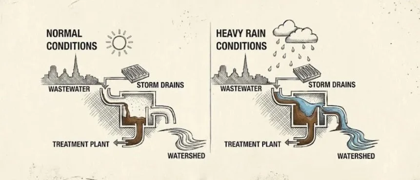
How a Combined Sewer Overflow (CSO) works
Compounding Sources of Flooding
Modern flood events rarely follow a single route. It is increasingly common to see fluvial flooding, high tide conditions, and surface water flooding all interacting. These situations create more complex risk profiles and require engineers to assess flooding at the catchment scale rather than from one source alone.
3. How Policy and Practice Are Changing
2025 National SuDS Standards
The government released updated National Standards for Sustainable Drainage Systems in 2025. The changes focus on slowing water close to its source and delivering multiple benefits, not only hydraulic performance. They set clearer expectations around:
reducing runoff volumes
improving water quality
supporting biodiversity
planning for long term maintenance
proving that discharge proposals are justified through evidence
For new developments, SuDS is now a core design requirement rather than a supplementary element.
Local Strategies and Urban Retrofit
Major cities, led by London, have introduced surface water management plans to retrofit older neighbourhoods. These plans rely on small, distributed interventions that collectively store or intercept water. Examples include rain gardens, tree pits, permeable paving, and shallow swales along streets.
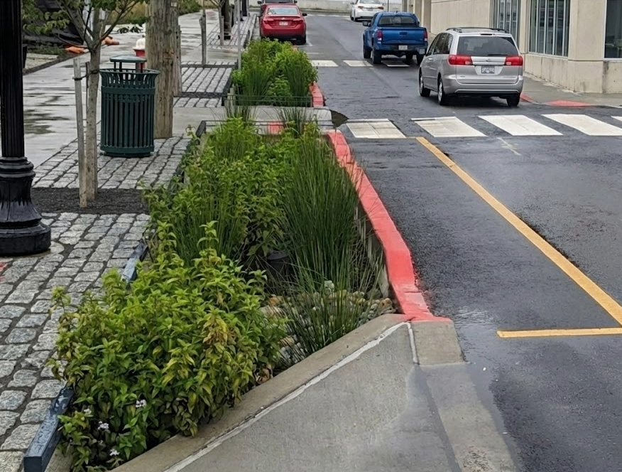
A retrofitted SuDS scheme showing a raingarden for highway drainage
Blue Green Infrastructure
Across the UK, projects are increasingly designed with multi functional infrastructure that manages water, supports biodiversity, and improves public space. Well known examples include large scale green corridors, swaled roads and highways, and developments that use open channels to move water slowly through the site.
These approaches help reduce runoff rates, offer public realm benefits, and create more adaptable landscapes.
Better Mapping and Data
The updated Flood Map for Planning includes improved surface water data, clearer climate uplift allowances, and enhanced mapping for groundwater and fluvial interactions. This is helping engineers prepare stronger flood risk assessments and more resilient drainage strategies.
4. Practical Challenges in Urban Areas
Legacy Infrastructure
Retrofitting SuDS into older areas can be technically challenging. Space is limited and utilities often sit directly beneath possible SuDS features. Construction work can be disruptive and may require significant temporary works or traffic management.
Maintenance Responsibilities
A frequent cause of SuDS failure is unclear ownership. The updated national standards place greater weight on long term maintenance planning. Engineers must ensure maintenance is realistic, affordable, and assigned to an organisation that is equipped to carry it out.
Development Pressure on Higher Risk Land
The demand for new housing puts consistent pressure on floodplain development. Engineers are often asked to find ways to make sites workable, even when constraints are significant. This requires careful use of modelling, compensatory storage design, and honest conversations with planners and clients about what is feasible.
5. Summary Table
| Impact | Mechanism | Area Most Affected | Source |
|---|---|---|---|
| Impermeable surfaces | Higher runoff and limited infiltration | Town and city centres | Internet Geography |
| Floodplain development | Reduced storage and quicker rise in river levels | New housing in low lying land | LSE |
| Drainage overload | Networks unable to manage intense storms | Older urban areas | ScienceDirect |
| Climate change | Heavier rainfall and more compound events | Nationwide | Holcim UK |
| Loss of green space | Less natural storage and interception | High density developments | British Red Cross |
Conclusion
Urbanisation is shaping flood risk across the UK in powerful ways. As towns and cities expand, natural drainage pathways reduce, older infrastructure reaches its limits, and climate change pushes rainfall beyond historical expectations. Every civil engineer now needs awareness of how water moves through urban environments and how to design spaces that can safely manage it.
The industry is responding with stronger SuDS policies, green and blue infrastructure, improved data, and a focus on multi functional solutions. These approaches will guide how we build and adapt our cities over the coming decades.
To stay sharp and continue developing your expertise, explore other articles on Civil Engineered for Success, share your thoughts in the comments, connect with the CEFS community, and subscribe to the newsletter to stay informed and inspired.
References
https://www.internetgeography.net/topics/why-is-the-risk-of-river-flooding-increasing-in-the-uk/
https://www.redcross.org.uk/stories/disasters-and-emergencies/uk/what-are-floods
https://www.unda.co.uk/news/2025-national-standards-for-sustainable-drainage-systems-suds/
https://www.sciencedirect.com/science/article/pii/S2214581817300435
https://urban-water.co.uk/flood-map-for-planning-enhanced-data-and-new-features-coming-march-2025/